The Budawangs is the colloquial name given to the area comprising Budawang National Park and the southern extent of Morton National Park, south-east of the Braidwood–Nowra road in southern New South Wales (Australia). In the late 1950s, the NSW Coast and Mountain Walkers started bushwalking there, and the area has since become a popular destination.
The Budawangs
View Budawangs - road acces points in a larger map
2019-2020 bushfires 🔗
This area was burnt extensively between December 2019 and February 2020 by the Currowan 2 and Charleys Forest bushfires. According to the NSW Rural Fire Service "Fires Near Me" map, the fires burnt through all the areas that I cover in this section, and much more besides. This includes all of the area between the Yadboro River (Long Gully campground) in the south and Sassafras in the north, and extending west to the Wog Wog campground and east to Little Forest Plateau. After 74 days, the Currowan 2 fire was declared "out" on 8 February 2020 after heavy rainfall in the area.
Please see the official NSW National Parks and Wildlife Service web pages for park and track closures:
The walks 🔗
Entrances 🔗
The best places to start a walk from are probably...
- Wog Wog. Probably my favourite. It's about half an hour by car from Braidwood on a mixture of sealed and usually good gravel roads. At the end of a walk this means you're also half an hour away from food and coffee if you time it right. From Wog Wog it's an easy one day walk to the Canowie or Burrumbeet Brook campsites, with plenty to see along the way, including Corang Arch and a spectacular panorama just beyond that as you're descending to the campsites.
-
Nerriga. A bit further from Braidwood, and not as well documented as the
other entrances. The entrance gate is at 35.1465598° S, 150.125312° E. See the
placemark on the map above. To get there…
- Turn east off the Nerriga Road onto Endrick River Road about 550m south of the Nerriga pub, immediately south of the Bindi Brook creek crossing.
- After about 1.2km, turn right onto Meangora Road
- After 3.4km, veer right and continue for another 800m to the locked gate. The gate has a map of the immediate area attached to it (see below) and a stile for walker access.
Note that there's no direct access to Endrick River firetrail from the locked gate without negotiating access with private landholders. You can access Alum Creek firetrail though, which runs south from the gate. - Sassafras. Even further from Braidwood, but closer to Nowra, so better access from the east. The carpark was moved about 7km back towards Sassafras from Newhaven Gap in the '90s, so these days there's quite a bit of flat fire-trail walking before you get to see anything much. Probably still provides the best access to Folly Point though.
- Long Gully (Yadboro). If you're coming in from the west along the Kings Highway, bear in mind that there's quite a bit of driving on hilly dirt roads to get to this one. This is more of a factor at the end of a walk when you're tired and it's likely to be dark. From the Kings Highway, turn onto the Western Distributor, then start navigating - there are a few turnoffs along the way. Mobile phone coverage is very patchy, so don't rely on online maps. From the Princes Highway to the east, you'll probably want to turn off somewhere around Termeil, but make sure you've got a decent offline or paper map handy. As the crow flies, the Long Gully entrance is pretty close to the base of The Castle, which makes an imposing site as you drive in, but there's almost 800m of elevation to gain if you want to walk to the top from here.
- Little Forest Plateau. Easy access from the coast near Milton, and very easy walking around the western clifftop of the plateau.
- Pigeon House. Mainly for the day walk up Mt. Pigeon House

Access map from the locked gate at the Nerriga entrance
Camping and walking restrictions 🔗
There are restrictions on where you can camp in The Budawangs. See the official requirements and guidelines here. Most notably, you cannot camp in Monolith Valley and Hidden Valley.
As appealing as they are, fires are not permitted at most of the popular camping areas. Amongst other considerations, there is just not enough fallen timber to sustainably support campfires.
Many of the cliffs have large rock overhangs or even caves at their bases, and camping is permitted in some of these — see the guidelines. Bear in mind that they're usually quite dusty and heavily used, and level spots for sleeping may be in short supply.
The Tianjara plateau area was once used as a firing range, and may contain unexploded ordinance, so keep to the tracks in this area.
As with everywhere, do your best to leave no trace.

Books 🔗
Maps 🔗
Most of the Budawangs is covered by four 1:25000 topographic maps, published by
the New South Wales Department of Lands.
- Corang 89273N
- Endrick 89274S
- Milton 89272N
- Tianjara 89271S
You can download and print sections of these from the official NSW map site
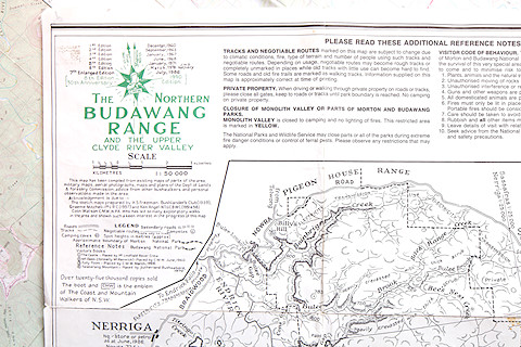
There's also the legendary "Budawangs sketch map" (The Northern Budawang Range and the Upper Clyde River Valley), first published by the Budawang Committee in 1960. I have the 8th edition, published in 1990, and I think that may well have been the last. It's not as useful now as it once was, as some of the tracks marked on it are overgrown and access points have moved. It also indicates a number of camping caves, some of which are now off-limits on environmental and cultural grounds.
Still, the sketch map is a charming document, with hand-drawn text and features giving it a bit of a J.R.R. Tolkien feel.
What's new in the "Budawangs" section 🔗
-
Updated Corang Loop. The track has changed a bit since my previous visit, and the land is still recovering from the 2019 bushfires. This update includes an alternative route off Corang Plateau.
-
First Budawangs trip after the 2019-2020 fires: Nerriga to Binnari Pass. The good news is that there's a lot of regrowth, but it's going to take years for the understory to reestablish and the wildlife to return.
-
Added a brief note about the recent bushfires that burnt through The Budawangs. The whole area is currently closed.
-
Added the Nerriga to Hollands Gorge via Folly Point and returnwalk
-
Updated directions to the Nerriga entrance of The Budawangs.